

Best Places to Take Photos on the Mach Loop: A Practical Guide from MotoCamp Wales
The Mach Loop offers some of the most exciting aviation photography in Wales, with fast military aircraft passing through dramatic mountain valleys. Here are four established viewpoints to consider during a stay at MotoCamp Wales, plus one flat alternative.
BEFORE YOU SET OUT
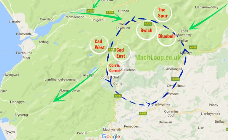
The Mach Loop is a military low-flying training area in Eryri (Snowdonia), between Dolgellau, Machynlleth and Dinas Mawddwy. Aircraft activity depends entirely on military training requirements, weather and operational conditions.
There is no public timetable, and seeing aircraft is never guaranteed. Plan for a mountain photography day rather than a guaranteed airshow.
MotoCamp Wales is a practical base near Dolgellau, with lodges, camping pods and limited pitches for visitors exploring the area. See our accommodation options before planning your trip.
THE BWLCH
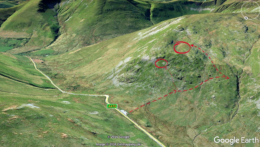
Best for: classic topside and wide valley photographs Walk: under 0.5 miles from the roadside parking Climb: approximately 200 feet to the middle ledge or 400 feet to the top Postcode: LL40 2SH
The Bwlch is one of the best-known Mach Loop viewpoints. From the hillside, you look down into the narrow valley as aircraft pass below and follow the contours of the landscape.
The top ledge gives the most elevated perspective, with aircraft framed against the valley floor and surrounding hills. The middle ledge offers a shorter climb and can be a useful option when the upper viewpoint is crowded or the weather is poor.
For photography, The Bwlch suits a long lens and a wide field of view. You may have a few seconds to track an approaching aircraft before it banks through the valley. This makes it a good location for topside images, banking shots and photographs that include the surrounding landscape.
The path is uneven and exposed, with rocky and grassy sections. Wear proper walking boots and allow extra time if you are carrying a large camera bag or tripod.
View the Mach Loop guide to The Bwlch for current location information.
CAD WEST
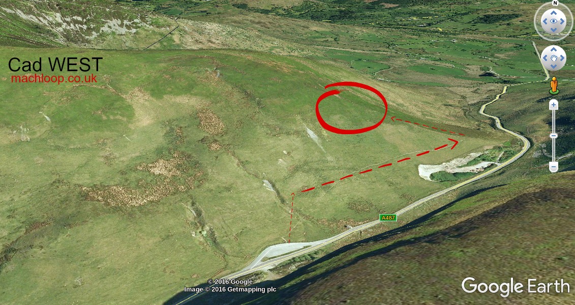
Best for: level-pass and profile photographs Walk: approximately 0.5 miles Climb: approximately 300 feet Postcode: LL40 2SH
Cad West offers a different angle from The Bwlch. Depending on where you position yourself on the hillside, aircraft can pass at a similar height to the camera, creating level or near-level profile shots.
Aircraft approach from the left, so keep your camera ready and maintain a clear view of the approach route. A suitable pass may also produce a banking photograph as the aircraft continues towards Corris Corner.
Cad West is a useful choice if you want variety. You can photograph the aircraft against the valley walls, capture side-on images and try panning techniques as the aircraft crosses your field of view.
A 70–200mm or 100–400mm zoom can be more flexible here than an extremely long prime lens. Aircraft may be closer than expected, and a lens that is too long can make it difficult to keep the whole aircraft in frame.
Access involves a moderate climb over open, uneven ground. Take care near fences, steep slopes and wet patches, and do not obstruct passing places or farm access when parking.
See the Cad West location guide before travelling.
CAD EAST
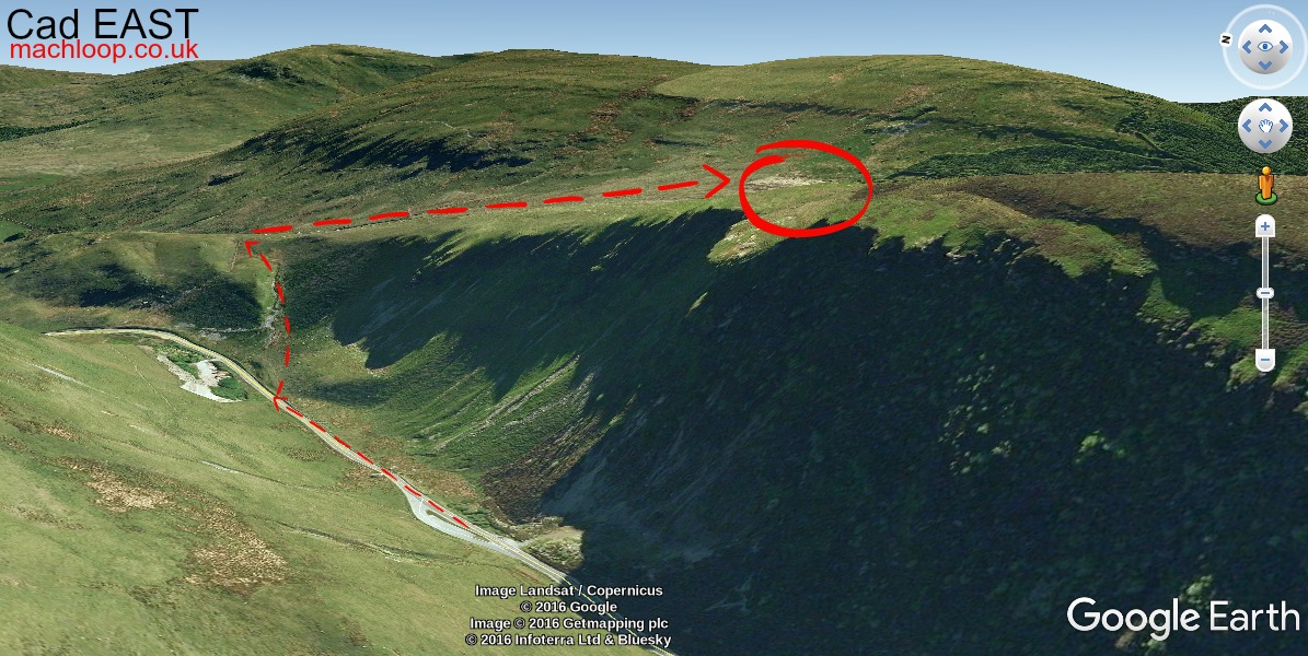
Best for: topside, banking and three-quarter front shots Walk: approximately one mile Climb: approximately 400 feet Postcode: LL40 2SH
Cad East gives photographers an elevated view across the valley, with aircraft arriving from the right and often visible for longer before the pass. This extra warning time can help when you are learning to track fast-moving aircraft.
The hillside position works well for topside images, three-quarter front views and photographs showing an aircraft banking against the mountain scenery. On a clear day, the wider views also bring depth to landscape compositions.
A long lens is useful at Cad East. Around 400–600mm equivalent gives you reach for tighter aircraft images, although a zoom gives greater flexibility when the distance and flight path change.
The walk is longer and steeper than Cad West, with rough ground, grass and loose stones. Conditions can become slippery after rain, and the exposed hillside can be windy. Carrying a heavy camera setup adds to the effort, so keep your kit practical.
Some access information refers to tracks and limited parking higher on the hill. These arrangements can change, and private tracks should not be used unless current local guidance clearly permits it. Never block farm access, and close every gate as you find it.
Read the Cad East guide for the latest practical details.
BLUEBELL HILL
Best for: dramatic upward photographs from below the flight line Walk: approximately 0.25 miles Terrain: steep descent of around 300 feet Postcode: SY20 9LX
Bluebell Hill provides a lower-level perspective beneath the main Bwlch flight line. Instead of looking down on aircraft, you look up as they cross the valley overhead.
This creates a strong sense of speed and scale. Try a wider composition that includes the sky, valley sides and aircraft, rather than relying only on tight aircraft portraits. An upward angle can also show the underside of the aircraft more clearly than the elevated viewpoints.
The walk is short but steep. Remember that the return journey involves climbing back up to the road, often while carrying camera equipment. The slope can be slippery in wet conditions, and the viewpoint has limited space.
Bluebell Hill is better suited to smaller groups. Set up without blocking the path, and leave room for other visitors to move safely.
Find the Bluebell Hill location guide before choosing this viewpoint.
A FLATTER ALTERNATIVE
Visitors who cannot manage a hill walk can consider Corris Craft Centre. It has on-site parking, level access and a valley-floor viewpoint where aircraft may pass overhead.
It does not provide the elevated angles of The Bwlch, Cad East or Cad West, but it offers a practical option for a mixed group or anyone unable to hike. Check opening arrangements and current access information before setting out.
USE THE RIGHT CAMERA SETTINGS
Fast military aircraft give you very little time to react. Start with:
A shutter speed of at least 1/1600 sec
1/2000 sec or faster when light allows
Continuous autofocus, such as AF-C or AI Servo
High-speed continuous shooting
A wide autofocus area or subject-tracking mode
Aperture around f/6.3 to f/8 where your lens and light allow
A 100–400mm or 150–600mm zoom is a versatile choice for a first visit. A wide-angle lens can also be useful for environmental images showing the aircraft within the mountain landscape.
Listen for aircraft before raising the camera. Watch the likely approach area, pre-focus where appropriate and begin shooting slightly earlier than feels necessary. It is easier to remove unwanted frames later than recover a missed pass.
PACK FOR THE MOUNTAINS
Weather changes quickly in the Welsh hills. Bring:
Waterproof jacket and trousers
Warm layers and gloves
Sturdy walking boots
Food and water
Spare batteries
Extra memory cards
A rain cover for your camera and lens
Lens cloths for rain and mist
A small tripod or monopod if useful for your setup
Keep batteries warm in an inside pocket during cold weather. Protect the camera before rain arrives, rather than waiting until the first shower. A monopod can support a long lens while still allowing you to track aircraft freely.
FOLLOW RESPONSIBLE ACCESS GUIDANCE
The Mach Loop is a working mountain landscape, not a controlled public event. Stay on permitted paths and open access land, and follow signs and current local guidance.
Respect private property. Do not cross fences, walls or gates to reach a better angle. Leave gates as you find them, avoid disturbing livestock and never block roads, passing places, gateways or farm tracks.
Take all litter home, including food waste and small packaging. Keep clear of roads when walking or photographing, and do not stand in places where you could affect traffic visibility.
Do not fly drones, model aircraft, kites or any other airborne device in or near the Mach Loop. Military aircraft operate at very low level and high speed, leaving no safe margin for recreational flying devices.
Check Eryri National Park’s Countryside Code before travelling, and use current maps and local notices to confirm access.
PLAN FOR THE EXPERIENCE
The best photograph may be a sharply tracked aircraft banking through the valley, a wide image with the mountains behind it or a frame that captures the atmosphere of waiting in the open hills.
However, the most important part of planning a Mach Loop visit is accepting that nothing may fly. Use the time to enjoy the landscape, practise tracking birds or aircraft at a distance, and take photographs of the valleys themselves.
Afterwards, return to MotoCamp Wales near Dolgellau to warm up, recharge your batteries and settle into a peaceful evening outdoors. Our things to do guide includes more ideas for exploring the surrounding area during your stay.
For visitors looking for camping in wales, our Dolgellau campsite provides a base for combining aviation photography with mountain walks, scenic roads and the wider adventures of southern Eryri.
Comments